VANCOUVER, British Columbia, Aug. 18, 2026 (GLOBE NEWSWIRE) — Vortex Energy Corp. (CSE: VRTX) (OTC: VTECF) (FSE: AA3) (“Vortex” or the “Company”) is pleased to announce the final results of the Ambient Noise Tomography (“ANT”) survey completed at the Company’s 100%-owned Robinsons River Salt Project (the “Project”), located approximately 35 kilometres south of Stephenville, Newfoundland and Labrador. Further to the Company’s September 16, 2025 announcement that field acquisition had been completed, the final ANT results add a 3D shear-wave velocity dataset to the geological, geophysical and drilling information being considered within the Company’s ongoing staged technical review of the Project.
The ANT survey successfully mapped broad subsurface velocity domains and lateral velocity changes that may reflect structural or lithological variation across the survey area. The computational model extends to approximately 3.8 kilometres and is considered to image the subsurface to at least 2.5 kilometres depth. The resulting model provides regional and structural context for the existing drilling, seismic and gravity information and is being considered as part of the Company’s ongoing integrated review. However, it does not sharply or uniquely resolve the boundaries of the interpreted salt structures, likely because of overlap between the shear-wave velocities of halite and the consolidated clastic sedimentary rocks that comprise much of the local stratigraphic sequence. Accordingly, the ANT results are being used as one component of the integrated interpretation and not as a standalone method for delineating salt.
3D Shear-Wave Velocity Model
The resulting shear-wave velocity model covers an area approximately 17.5 kilometres east-west by 9.24 kilometres north-south. It extends to a maximum depth of approximately 3.8 kilometres and is considered to image the subsurface to at least 2.5 kilometres depth. Modelled shear-wave velocities range from approximately 1,100 metres per second near surface to approximately 4,450 metres per second at depth.
Three broad velocity domains were identified. The upper few hundred metres are generally characterized by velocities below approximately 1,500 metres per second. An intermediate, laterally variable domain extends to approximately 2.0 to 2.5 kilometres depth and generally ranges from approximately 2,000 to 4,000 metres per second. A deeper, more homogeneous domain is generally characterized by velocities above approximately 4,000 metres per second.
A depth-normalized velocity-contrast model further highlights lateral velocity variation within the survey area. One of the most persistent features is a northeast-trending velocity discontinuity along the eastern part of the model that may represent a major structural or lithological boundary. Persistent higher-velocity zones along the eastern survey margin and below approximately two kilometres depth may reflect metasedimentary and granitic rocks similar to those exposed southeast of the survey area. These features remain geological interpretations of velocity variations and have not been confirmed as specific contacts or rock types.
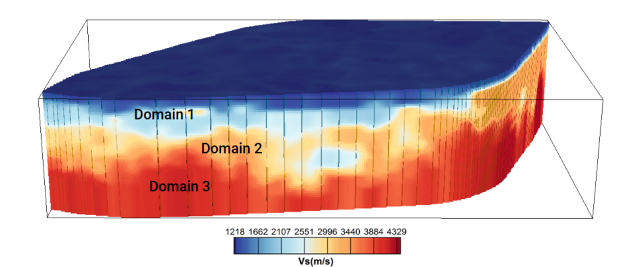
Figure 1. 3D shear-wave velocity model generated from the Robinsons River ANT survey, viewed looking north. Cool colours represent lower shear-wave velocities and warm colours represent higher shear-wave velocities. The model identifies three broad velocity domains and extends computationally to approximately 3.8 kilometres depth; CAUR concludes that the model images the subsurface to at least 2.5 kilometres depth. Source: CAUR Technologies Inc., Vortex Energy – Robinsons River Salt, CAU-25-023 – Ambient Noise Tomography Survey, Final Report.
Integration with Existing Technical Information
Comparison of the previously interpreted salt outlines derived from active seismic modelling with the ANT model shows that those interpretations coincide approximately with areas of lower shear-wave velocity. However, lower shear-wave velocity is not unique to salt, and the ANT results alone cannot determine the boundaries, thickness, composition or continuity of the interpreted salt structures. Because the prior outlines were used in the comparison itself, this spatial association should not be considered independent confirmation of those structures.
The ANT results were also compared with the FALCON airborne gravity gradiometry data and the 3D density inversion available at the time of the analysis. This comparison showed moderate to low density variation and subtle density contrasts spatially associated with the previously interpreted salt structures. The Company is also considering the ANT velocity model alongside legacy seismic data and recent drilling information and core data within its ongoing staged technical review.
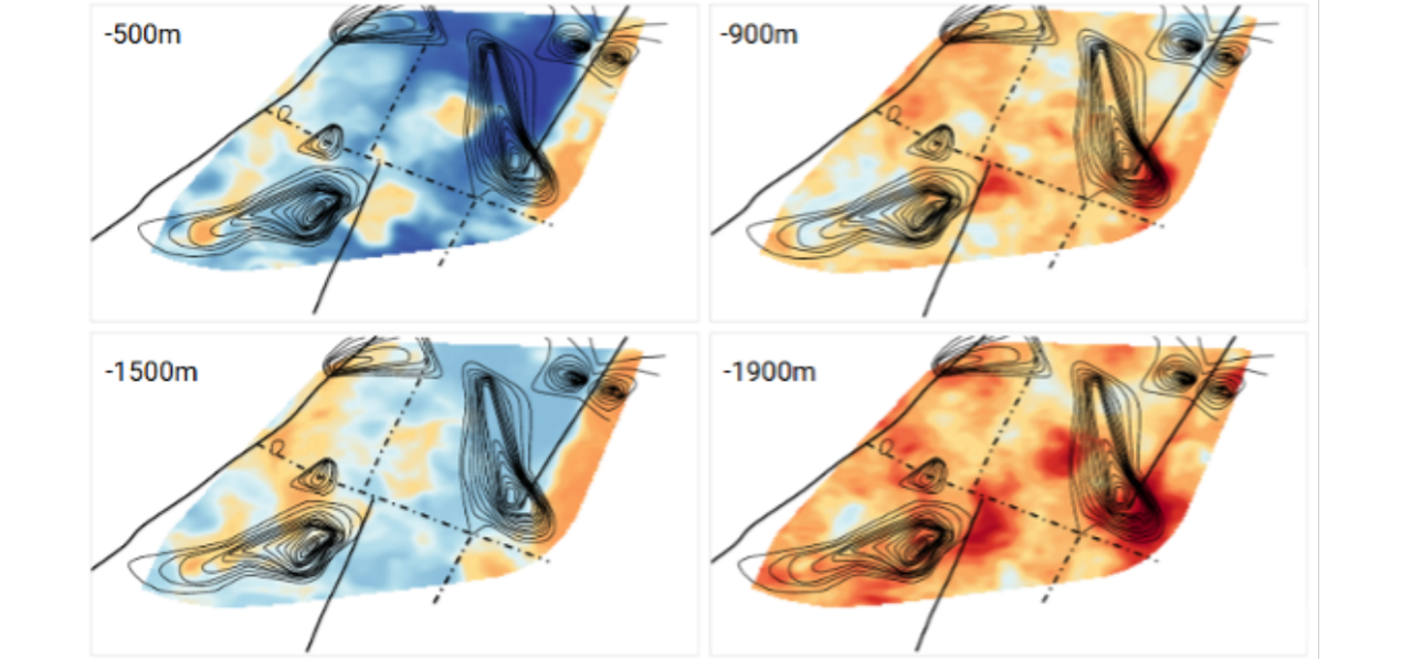
Figure 2. Plan-view slices from the 3D ANT shear-wave velocity model at approximately 500, 900, 1,500 and 1,900 metres below surface. Black contours show the previously interpreted salt isopachs derived from active-seismic modelling, while solid and dashed black lines show mapped and inferred faults, respectively. The spatial association between the pre-existing salt interpretations and lower-velocity zones is approximate, and the ANT model did not independently resolve the boundaries of the interpreted salt structures. Source: CAUR Technologies Inc., Vortex Energy – Robinsons River Salt, CAU-25-023 – Ambient Noise Tomography Survey, Final Report.
Ongoing Technical Review
The ANT velocity and contrast models are being considered as an additional dataset within the Company’s ongoing geological, geophysical and commercial review. The current stage remains focused on review and analysis of existing core and technical information, including detailed review and analysis of the VTX-24-W-02 core, representative density measurements, determination of salt percentage by volume, desktop evaluation of available information concerning source-water and disposal requirements, refinement of the integrated geological and geophysical model, and land-package optimization.
“Completing the ANT survey is another meaningful step forward for Robinsons River, adding a property-scale 3D view of the subsurface to our growing body of technical data,” said Paul Sparkes, Chief Executive Officer of Vortex. “By mapping broad velocity changes and highlighting potential structural and lithological boundaries, this dataset sharpens the geological framework and adds real value to our integrated interpretation. Layered together with our drilling, seismic, gravity and core data, these results give us growing confidence in the model as we advance the project through its staged technical review and work toward unlocking the full potential of this district-scale salt opportunity.”
Collaboration and Acknowledgements
The ANT program was conducted in collaboration with the University of Alberta. Specialized survey design, instrumentation and data processing were provided by CAUR Technologies. The research collaboration was supported in part by a Mitacs grant. The Company also acknowledges the financial support of the Junior Exploration Assistance (JEA) Program, administered by the Department of Industry, Energy and Technology, Government of Newfoundland and Labrador.
Qualified Person
The scientific and technical content of this news release has been reviewed and approved by Jared Suchan, Ph.D., P.Geo., Vice President of Exploration of the Company and a “Qualified Person” as defined by National Instrument 43-101.
The Qualified Person verified the ANT information disclosed in this news release through review of the survey documentation provided by CAUR Technologies, including the acquisition and instrument-recovery summaries, data-quality assessments, processing methodology, model outputs and interpretations. Quality-control measures included checks of instrument operating duration and recovery, assessment of cross-correlation signal-to-noise behaviour and stability, and evaluation of the dominant directional noise source from the Gulf of St. Lawrence, which was accounted for during processing and inversion. The Qualified Person did not independently reprocess the raw passive-seismic dataset or recreate the 3D inversion and has relied on CAUR for those specialist technical components. No sampling or laboratory analytical work was involved in the ANT survey.
For additional information concerning the Project and the Company’s data-verification and quality-assurance procedures, readers are referred to the Company’s technical report entitled Independent Technical Report on the Robinsons River Salt Property, dated July 31, 2023, available under the Company’s profile on SEDAR+.
About Vortex Energy Corp.
Vortex Energy Corp. is an exploration stage company engaged principally in the acquisition, exploration, and development of mineral properties in North America. The Company is currently advancing its Robinson River Salt Project comprised of a total of 942 claims covering 23,500 hectares located approximately 35 kilometres south of the town of Stephenville in the Province of Newfoundland & Labrador. The Robinson River Salt Project is prospective for both salt and hydrogen salt cavern storage. The Company is also currently advancing its Fire Eye Uranium Property in the Athabasca Basin, a region renowned for its uranium deposits.
On Behalf of the Board of Directors
Paul Sparkes
Chief Executive Officer, Director
+1 (778) 819-0164
info@vortexenergycorp.com
Cautionary Note Regarding Forward-Looking Statements
Certain statements contained in this press release constitute forward-looking information. These statements relate to future events or future performance. The use of any of the words “could”, “intend”, “expect”, “believe”, “will”, “projected”, “estimated” and similar expressions and statements relating to matters that are not historical facts are intended to identify forward-looking information and are based on the Company’s current beliefs or assumptions as to the outcome and timing of such future events. In particular, this press release contains forward-looking information relating to, among other things, the Company’s exploration plans at the Project.
Various assumptions or factors are typically applied in drawing conclusions or making the forecasts or projections set out in forward-looking information, including, in respect of the forward-looking information included in this press release, assumptions regarding the Company’s ability to execute on its exploration plans, including that it will be successful in carrying out the planned drilling and that such drilling will yield the expected information and the desired outcomes.
Although forward-looking information is based on the reasonable assumptions of the Company’s management, there can be no assurance that any forward-looking information will prove to be accurate. Forward-looking information involves known and unknown risks, uncertainties and other factors which may cause the actual results, performance or achievements to be materially different from any future results, performance or achievements expressed or implied by the forward-looking information. Such factors include, among other things, the risk that exploration at the Project does not proceed in the manner and on the timeline currently contemplated, or at all; risks inherent in the exploration and development of mineral deposits, including risks relating to receiving requisite permits and approvals, changes in project parameters or delays as plans continue to be redefined, that mineral exploration is inherently uncertain and that the results of mineral exploration may not be indicative of the actual geology or mineralization of a project; and that mineral exploration may be unsuccessful or fail to achieve the results anticipated by the Company, including as a result of factors beyond the Company’s control, such as geological conditions. The forward-looking information contained in this release is made as of the date hereof, and the Company not obligated to update or revise any forward-looking information, whether as a result of new information, future events or otherwise, except as required by applicable securities laws. Because of the risks, uncertainties and assumptions contained herein, investors should not place undue reliance on forward-looking information. The foregoing statements expressly qualify any forward-looking information contained herein.
The Canadian Securities Exchange has not reviewed, approved, or disapproved the contents of this press release.
Photos accompanying this announcement are available at:
https://www.globenewswire.com/NewsRoom/AttachmentNg/fab8ba50-09f2-4a22-bfbd-5e2e1eae3663
https://www.globenewswire.com/NewsRoom/AttachmentNg/484fe765-4ea9-4930-a6b4-352edcbfec4d